Ye, X., Li, S., Gao, G., Retchless, D., Cai, Z., Newman, G., … & Duffield, N. (2024). 3D visualization of hurricane storm surge impact on urban infrastructure. Urban Informatics, 3(1), 1-14.
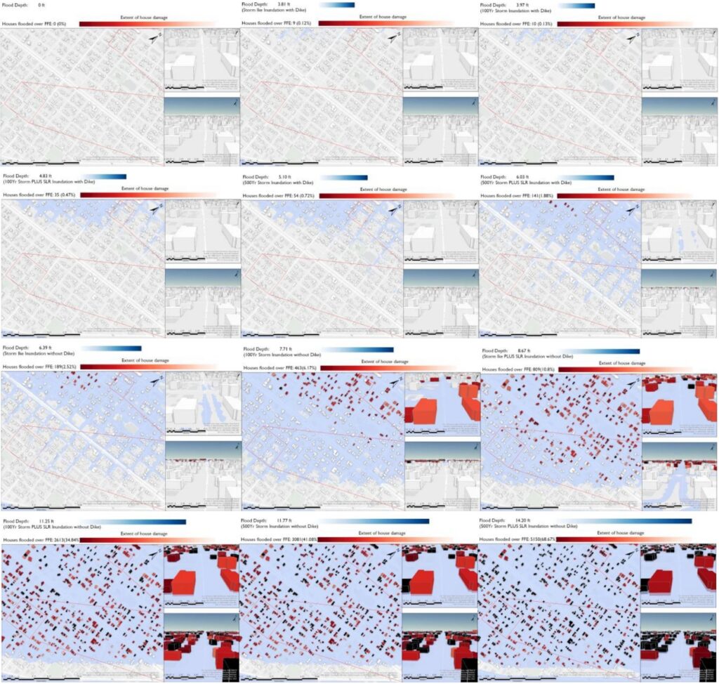
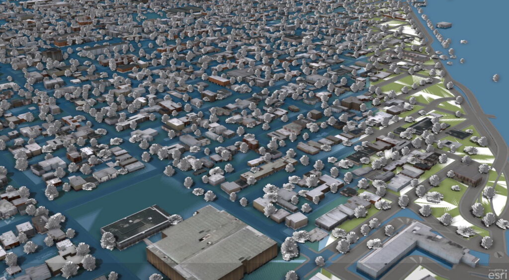
This study offers a 3D visualization of the repercussions of hurricane storm surge flooding on Galveston, TX residences, illustrating the impact on each structure and road across varied storm conditions. We employ target detection to pinpoint house door locations, using door inundation as a metric to gauge potential flood damage. Within a GIS-based framework, we model the damage scope for residences exposed to varying storm intensities. Our research achieves three core goals: 1) Estimating the storm inundation levels on homes across different storm conditions; 2) Assessing first-floor elevations to categorize housing damages into three distinct groups; and 3) Through visualization, showcasing the efficacy of a proposed dike designed to shield Galveston Island from future storm surge and flood events.
Ye, X., Jamonnak, S., Van Zandt, S., Newman, G., & Suermann, P. (2024). Developing campus digital twin using interactive visual analytics approach. Frontiers of Urban and Rural Planning, 2(1), 9.
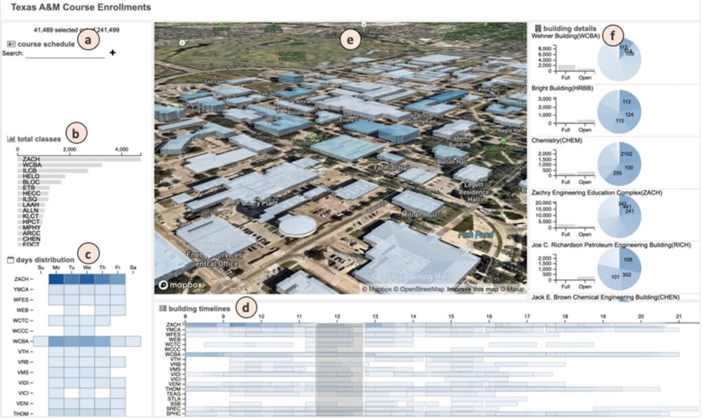
Digital Twins (DTs) are increasingly recognized for their potential to improve efficiency and decision-making in various domains of the built environment. Despite their promise, challenges like cost, complexity, interoperability, and data integration remain. This paper introduces a novel interactive visual analytics system that tackles these issues, using a case study of simulating class distribution and campus building capacity at a large public university. The system leverages enrollment data, converting it into a spatial-temporal format for interactive exploration and analysis of class distribution and resource utilization. Through case studies, we demonstrate the system’s effectiveness, adaptability, and real-world applicability, highlighting its role in practical DT implementation for built environments.
Ye, X., Du, J., Han, Y., Newman, G., Retchless, D., Zou, L., Ham, Y., & Cai, Z. (2023). Developing Human-Centered Urban Digital Twins for Community Infrastructure Resilience: A Research Agenda. Journal of Planning Literature, 38(2), 187-199.
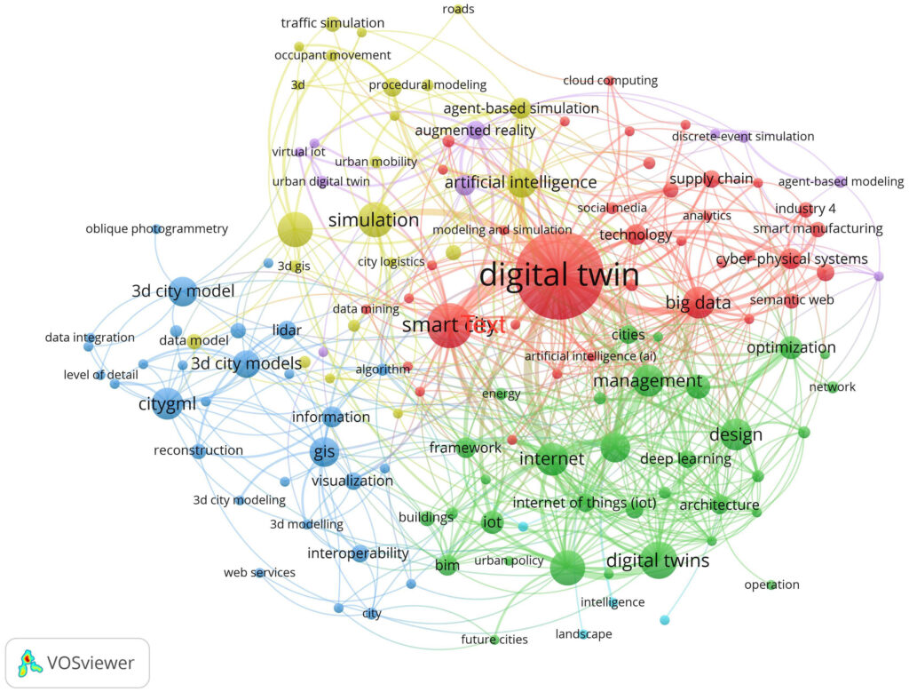
Urban digital twins (UDTs) have been identified as a potential technology to achieve digital transformative positive urban change through landscape architecture and urban planning. However, how this new technology will influence community resilience and adaptation planning is currently unclear. This article: (1) offers a scoping review of existing studies constructing UDTs, (2) identifies challenges and opportunities of UDT technologies for community adaptation planning, and (3) develops a conceptual framework of UDTs for community infrastructure resilience. This article highlights the need for integrating multi-agent interactions, artificial intelligence, and coupled natural–physical–social systems into a human-centered UDTs framework to improve community infrastructure resilience.
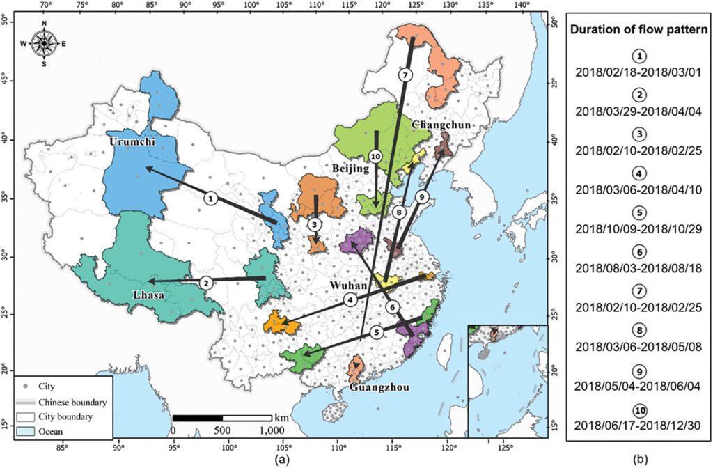
Zhang, H., Zhou, X., Ye, X., Tang, G., Wang, H., & Jiang, S. (2023). Strength-weighted flow cluster method considering spatiotemporal contiguity to reveal interregional association patterns. GIScience & Remote Sensing, 60(1), 2252923.
One of the most crucial topics in spatial interaction studies is mining patterns from extensive origin-destination (OD) flow data to capture interregional associations. However, prevailing methodologies tend to disregard the importance of using the relative closeness of interregional connections as weights, treat spatial and temporal dimensions independently, or overlook the temporal dimension completely. Consequently, the identified patterns are susceptible to inaccuracies, and the precise identification of pattern occurrence time and duration, despite their fundamental importance, remains elusive. In light of these challenges, this study proposes a strategy to calculate and combine the strength of weighted spatiotemporal flows, and develops a clustering method and evaluation metrics based on this framework.
Cai, Z., Newman, G., Lee, J., Ye, X., Retchless, D., Zou, L., & Ham, Y. (2023). Simulating the spatial impacts of a coastal barrier in Galveston Island, Texas: a three-dimensional urban modeling approach. Geomatics, Natural Hazards and Risk, 14(1), 2192332.
Due to its vulnerability to hurricanes, Galveston Island, TX, USA, is exploring the implementation of a coastal surge barrier (also referred to as the ‘Ike Dike’) for protection from severe flood events. This research evaluates the predicted effects that the coastal spine will have across four different storm scenarios, including a Hurricane Ike scenario and 10-year, 100-year, and 500-year storm events with and without a 2.4 ft. sea level rise (SLR). To achieve this, we develop a 1:1 ratio, 3-dimensional urban model and ran real-time flood projections using ADCIRC model data with and without the coastal barrier in place.
Li, X., Rybarczyk, G., Li, W., Usman, M., Bian, J., Chen, A., & Ye, X. (2023). How do people perceive driving risks in small towns? A case study in Central Texas. Accident Analysis & Prevention, 193, 107285.
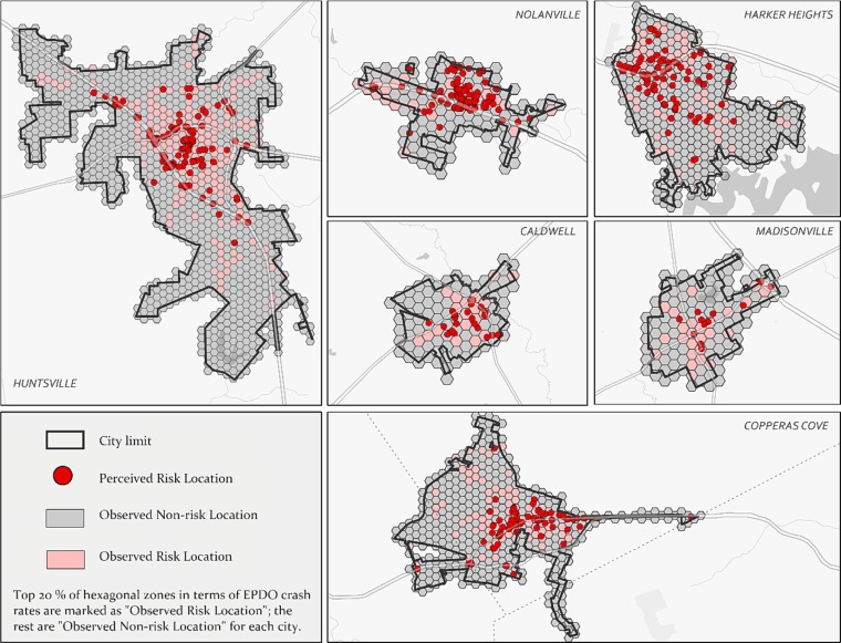
This study aims to investigate this dynamic within an understudied transportation environment – small towns in Texas, USA, defined as incorporated places with a population of less than 50,000. A web-based survey was distributed to six small towns in central Texas to ascertain perceptual traffic risk factors and personal characteristics. A participatory GIS exercise was also conducted to collect where high-risk locations were perceived and to correlate them to high crash zones. This study spatially examined the relations between perceived and observed risk locations and statistically identified a set of contributing factors which could make crash-intensive areas more perceivable by road users. The results indicated that road users’ perceived risk locations are not always associated with high crash rates. The match rate between perceived and observed risk locations varied significantly across studied sites.
Gong, X., Peng, S., Lu, Y., Wang, S., Huang, X., & Ye, X. (2023). Social Network Analysis of Nonprofits in Disaster Response: The Case of Twitter During the COVID-19 Pandemic in the United States. Social Science Computer Review, 41(6), 2029-2054. https://doi.org/10.1177/08944393221130674
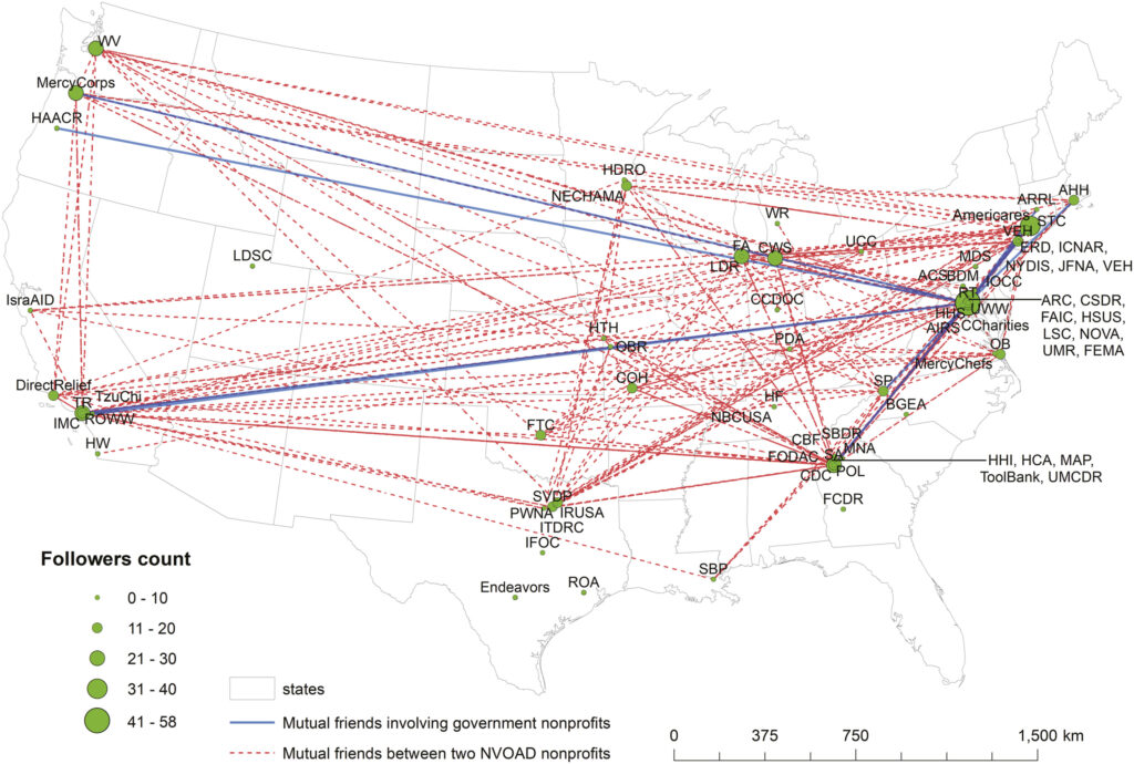
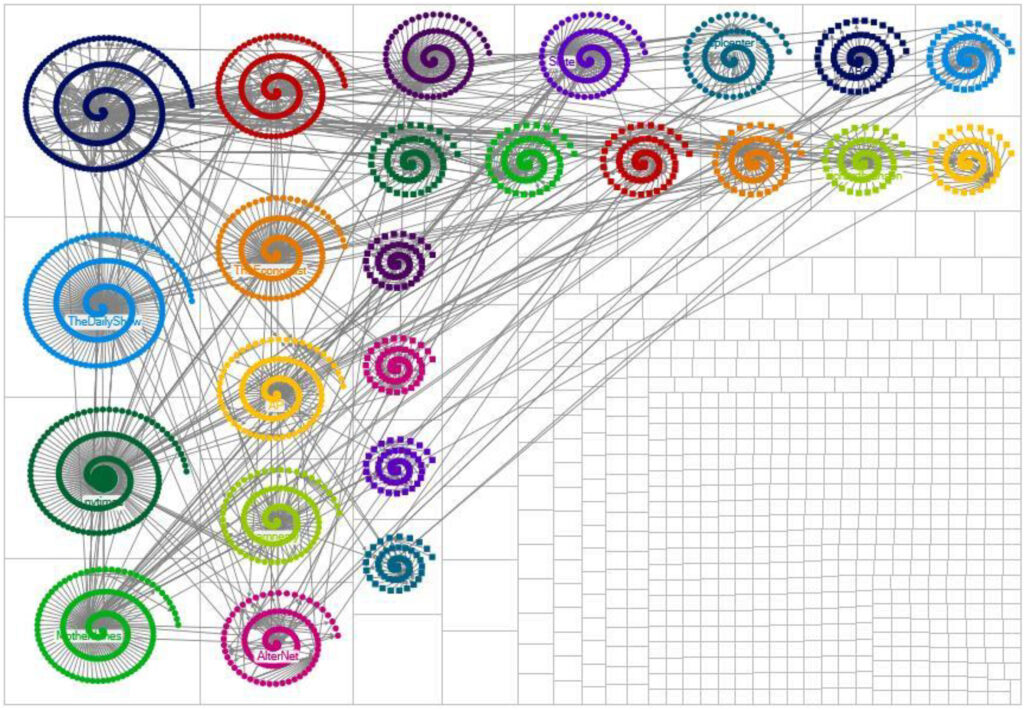
This study innovatively investigated the connection and interaction patterns among 74 National Voluntary Organizations Active in Disaster (NVOAD) nonprofits and three government agencies based on structural analyses and content analyses of their Twitter communications during the long-term global COVID-19 pandemic. The daily tweeting quantities of all nonprofits were generally consistent with the pandemic severity in the United States before July 2020 and remained stable afterward. Nonprofits’ tweets can reflect their purposes of sharing information, building communities, and taking actions for disaster response.
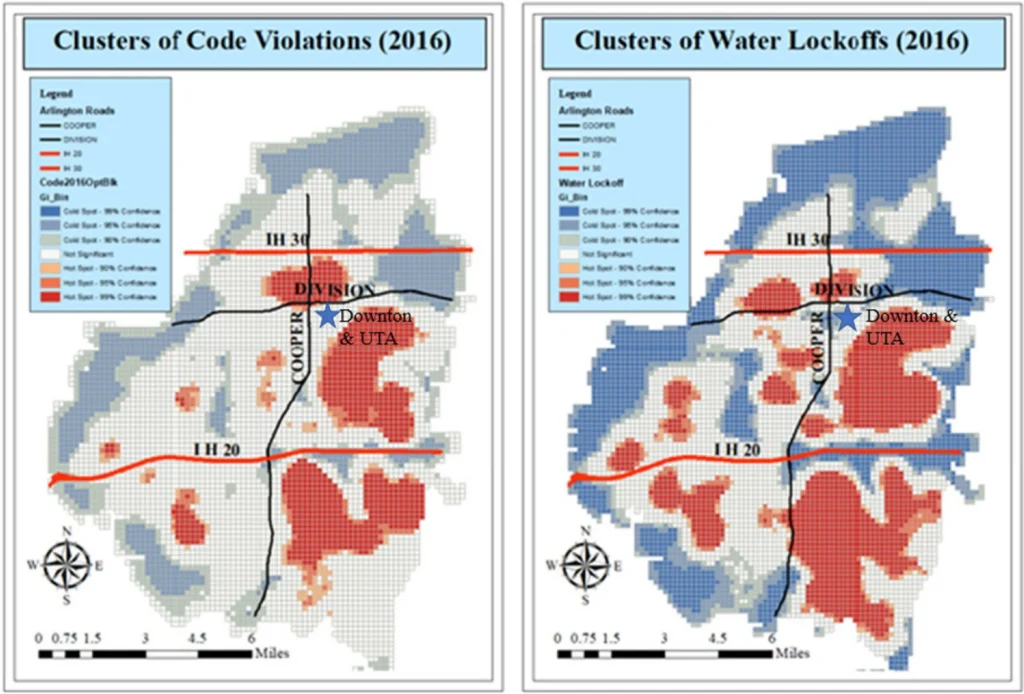
Li, J., Zhou, Y. & Ye, X. Data-driven service planning in the Petabyte Age: the case of Arlington, Texas. Urban Info 2, 5 (2023). https://doi.org/10.1007/s44212-023-00030-8
Using the City of Arlington, Texas as a case study, this research explores a hybrid approach for social inquiries with the aid of WOC and spatial learning techniques to leverage data for developing predictive models to support a city’s service planning. The results indicate that there exist temporal and spatial patterns of service demands, spatial correlation between demands for code compliance and water services, as well as association with neighborhood characteristics. The findings point to opportunities for further data integration and data mining, organizational collaboration, and resource management to improve the efficiency of service provision in cities.
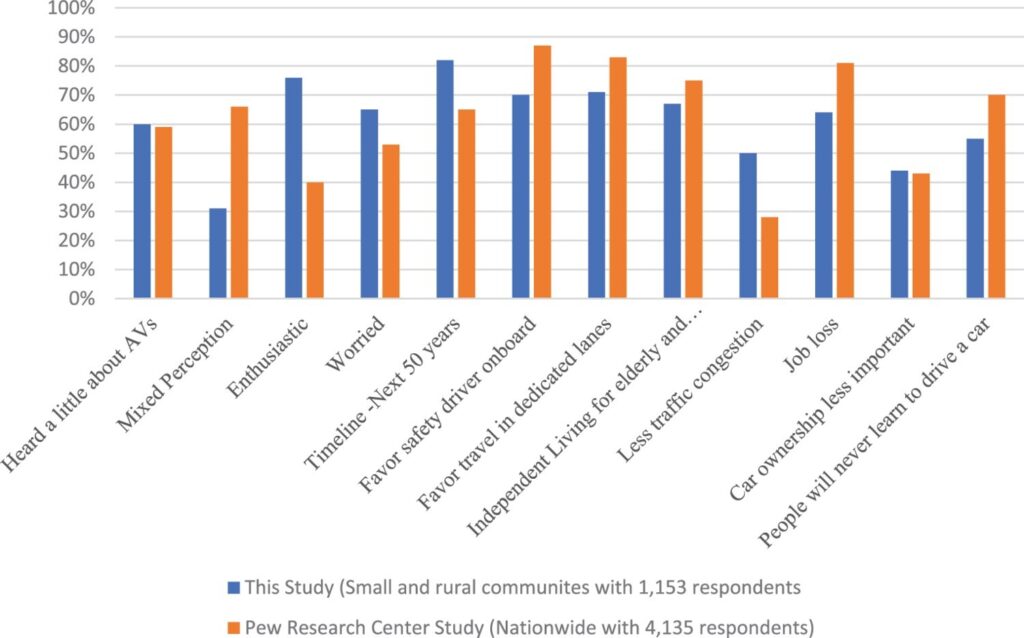
Usman, M., Li, W., Bian, J., Chen, A., Ye, X., Li, X., … & Ory, M. (2023). Small and rural towns’ perception of autonomous vehicles: insights from a survey in Texas. Transportation Planning and Technology, 1-26.
This study provides a unique perspective regarding perceptions of impacts of AVs in small and rural communities through an online survey in Central Texas (n = 1153). Our questionnaires gathered basic socio-demographic characteristics and AV impacts variables identified from the literature. We used summary statistics and ordered logistic regression models to reveal the perceived impacts of AVs. Residents of small and rural communities, particularly older adults (65 + years), were more enthusiastic about the development of AVs than the national average.
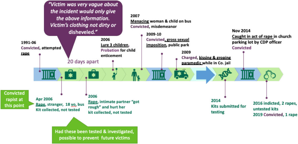
Lovell, R. E., Klingenstein, J., Du, J., Overman, L., Sabo, D., Ye, X., & Flannery, D. J. (2023). Using machine learning to assess rape reports:“Signaling” words about victims’ credibility that predict investigative and prosecutorial outcomes. Journal of Criminal Justice, 88, 102107.
The second of two articles from a larger study whose aim was to teach a computer to detect innuendo (or signaling) about a victim’s credibility in incident reports of rape. This study explored if the words expressed or not expressed, intentionally or not, influenced case progression and outcomes.
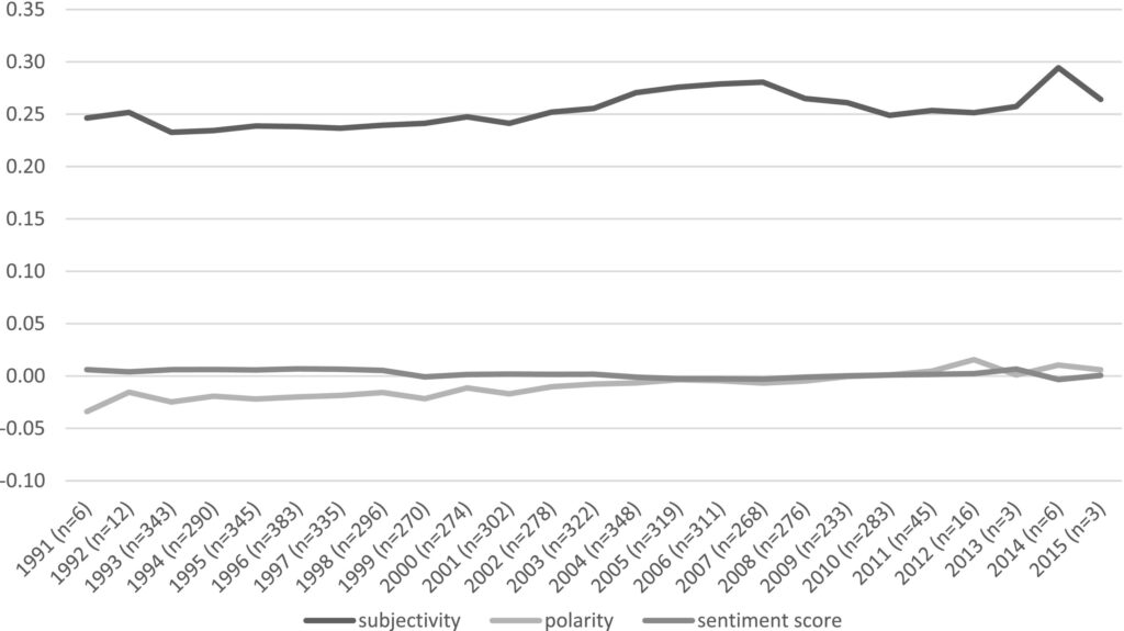
Lovell, R. E., Klingenstein, J., Du, J., Overman, L., Sabo, D., Ye, X., & Flannery, D. J. (2023). Using machine learning to assess rape reports: Sentiment analysis detection of officers’“signaling” about victims’ credibility. Journal of Criminal Justice, 88, 102106.
We taught a computer to detect signaling via tone that predicted case progression and outcomes. Findings indicate that the cases recommended for prosecution were longer and had positive sentiment and positive subjectivity. Cases not recommended for prosecution were shorter with more neutral statements of “fact” or observations. Implications and recommendations for improved, less biased report writing are provided.
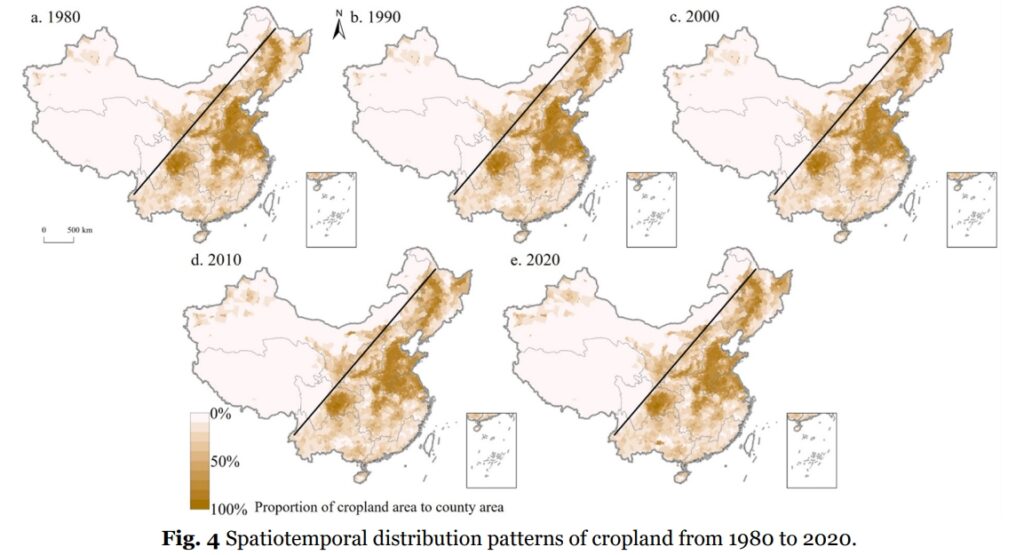
Yuan, J. T., Chen, W. X., Zeng, J., & Ye, X. Y. (2023). Exploring the rules of cropland elevation uplift in China. Journal of Mountain Science, 20(7), 1824-1841.
e analyzed the spatio-temporal evolution and multi-scale CLEU in China from 1980 to 2020 using the Lorenz curve, gravity center model, hotspot analysis, and cropland elevation spectrum. The results indicated that the center of gravity of cropland moved to the northeast from 1980 to 2000 and then shifted to the northwest. The spatial distribution of cropland became increasingly imbalanced from 1980 to 2000. The change hotspots clustered in the northwest and the northeast, whereas cold-spots were mainly in southeastern China. The average elevation of cropland increased by 17.38 m, and the elevation uplift rule in different regions differed evidently across scales. From 1980 to 2000, all provinces except Xinjiang, Inner Mongolia, Gansu, and Yunnan exhibited CLEU, with Qinghai, Tibet, Beijing, and Guangdong showing the most noticeable uplifting.
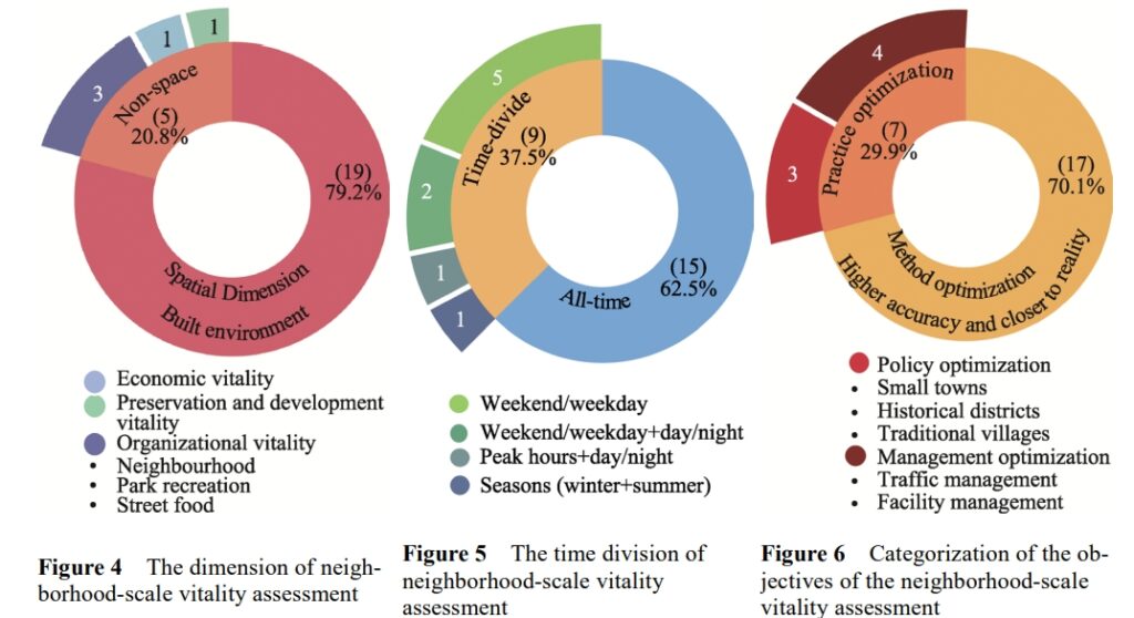
Liu, S., Ge, J., Ye, X., Wu, C., & Bai, M. (2023). Urban vitality assessment at the neighborhood scale with geo-data: A review toward implementation. Journal of Geographical Sciences, 33(7), 1482-1504.
This study aims to fill the research gap by exploring the content and methods of vitality assessment that can make urban vitality research more compatible with policy, planning, and design practice. We chose the neighborhood scale, which is the most practical initiative unit for vitality enhancement. We discovered that the gaps between the current research and practice primarily lie in the diversity of research subjects, the authenticity and comprehensiveness of vitality measurement, and the multi-domain of impact factor analysis. On this basis, we classified the following expandable aspects: (1) multi-type, multi-dimensional, multi-temporal, and implementation-adaptive vitality evaluation; (2) methods reflecting high-quality social interactions and the perceptions of vulnerable groups; (3) how design and urban management impacts vitality; and (4) the synergistic effects of multiple indicators on vitality.
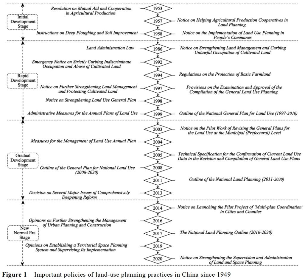
Chen, W., Pan, S., & Ye, X. (2023). Land-use planning in China: Past, present, and future. Journal of Geographical Sciences, 33(7), 1527-1552.
To bridge the existing gap, this study traced back to the emergence of LUP, described its practice stages, and analysed the evolution of its classification system and methods. Further, the three rounds of general LUP practice and the current TSP over the past 40 years of the reform and opening-up have been discussed. The evolution of LUP was found to be closely related to economic development and could be broadly divided into four stages. The development of land-use classification in China has been slow and can be divided into five stages according to the evolution of the land classification system and important historical events. The development of LUP methods can be divided into two stages, before and after 1978. Since the economic reform, China has successively conducted three rounds of general LUP under different institutional and policy backgrounds.
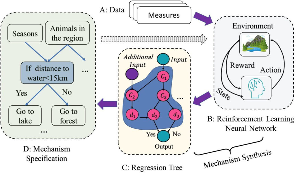
An, L., Grimm, V., Bai, Y., Sullivan, A., Turner II, B. L., Malleson, N., … & Tang, W. (2023). Modeling agent decision and behavior in the light of data science and artificial intelligence. Environmental Modelling & Software, 105713.
Agent-based modeling (ABM) has been widely used in numerous disciplines and practice domains, subject to many eulogies and criticisms. This article presents key advances and challenges in agent-based modeling over the last two decades and shows that understanding agents’ behaviors is a major priority for various research fields. We demonstrate that artificial intelligence and data science will likely generate revolutionary impacts for science and technology towards understanding agent decisions and behaviors in complex systems. We propose an innovative approach that leverages reinforcement learning and convolutional neural networks to equip agents with the intelligence of self-learning their behavior rules directly from data. We call for further developments of ABM, especially modeling agent behaviors, in the light of data science and artificial intelligence.
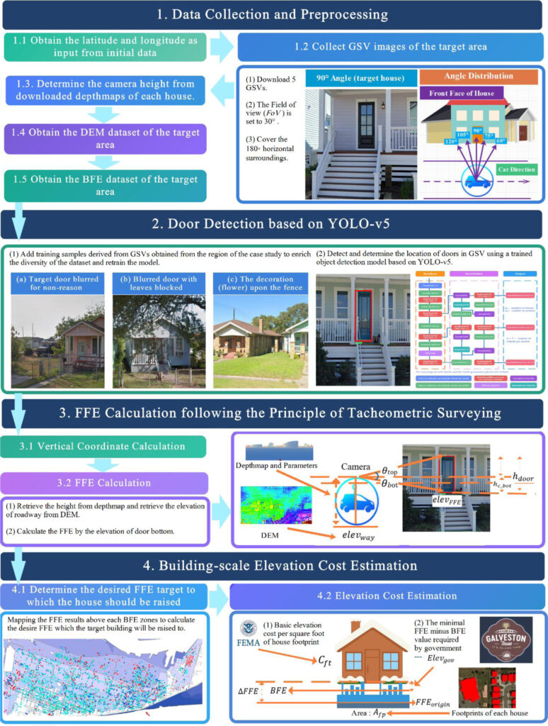
Gao, G., Ye, X., Li, S., Huang, X., Ning, H., Retchless, D., & Li, Z. (2023). Exploring flood mitigation governance by estimating first-floor elevation via deep learning and google street view in coastal Texas. Environment and Planning B: Urban Analytics and City Science, 23998083231175681.
Raising the First-Floor Elevation (FFE) above the base flood elevation (BFE) is an effective mitigation measure for buildings with a high risk of flooding. In the U.S., measuring FFE is necessary to obtain an Elevation Certificate (E.C.) for the National Flood Insurance Program (NFIP) and has traditionally required labor-consuming field surveys. However, the advances in computer vision technology have facilitated the handling of large image datasets, leading to new FFE measurement approaches. Taking Galveston Island (including the cities of Galveston and Jamaica Beach) in Coastal Texas as a case study, we explore how these new approaches may inform flood risk management and governance, including how FFE estimates may be combined with BFE estimates from flood inundation probability mapping to model the predicted cost of raising buildings’ FFE above their BFE. After establishing the FFE model’s accuracy by comparing its results with previously validated FFE estimates in three districts of Galveston, we generalize the workflow to building footprints across Galveston Island.
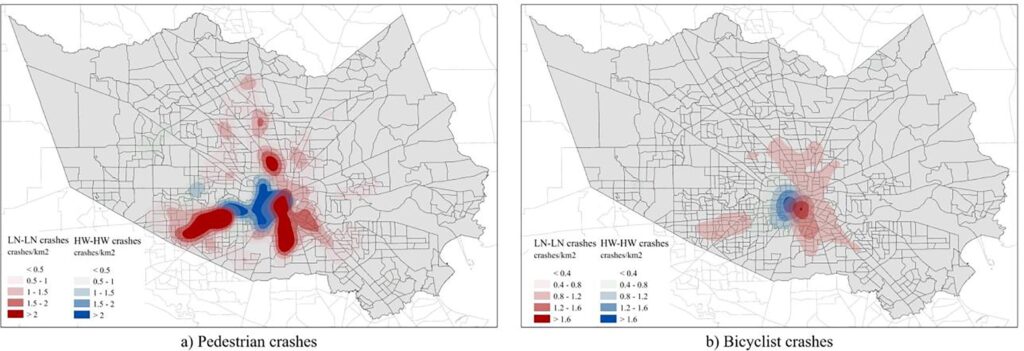
Zhu, C., Brown, C. T., Dadashova, B., Ye, X., Sohrabi, S., & Potts, I. (2023). Investigation on the driver-victim pairs in pedestrian and bicyclist crashes by latent class clustering and random forest algorithm. Accident Analysis & Prevention, 182, 106964.
In this study we paired the driver and pedestrian/bicyclist involved in the same crash to understand the socioeconomic and demographic make-up of the two parties involved in crashes and assessed the geographic distribution of these crashes and crash-contributing factors. For this purpose, we applied the latent class clustering analysis (LCA) to classify different crash types and analyze the patterns of the crashes based on the income and ethnicity of both drivers and victims involved in pedestrian and bicyclist crashes. We then used random forest algorithms and partial dependence plots (PDPs) to model and interpreted the contributing factors of the clusters in both pedestrian and bicyclist models. The clustering results showed a pattern of social segregation in pedestrian and bicyclist crashes that drivers and victims with similar socioeconomic characteristics tend to be involved in one crash. Pedestrian/bicyclist exposure, driver’s age, victim’s age, year of the car in use, annual average daily traffic (AADT), speed limit, roadbed width, and lane width were the most influential factors contributing to this pattern. Crashes that involved drivers and victims with lower income and non-white ethnicity tended to happen in the location with higher pedestrian/bicyclist exposure, higher speed limit, and wider road.
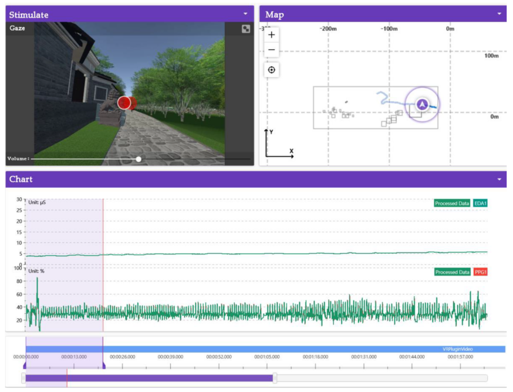
Lin, Z., Yang, Z., & Ye, X. (2023). Immersive Experience and Climate Change Monitoring in Digital Landscapes: Evidence from Somatosensory Sense and Comfort. International journal of environmental research and public health, 20(4), 3332.
The virtual engine software (Unity 2019, Unity Software Inc., San Francisco, California, the U.S.) was used to generate a digital landscape model, forming a virtual immersive environment. Through field investigation and emotional preference experiments, the ancient tree ecological area and the sunlight-exposed area were respectively monitored, and the somatosensory comfort evaluation model was established. The subjects showed the highest degree of interest in the ancient tree ecological area after landscape roaming experience, and the mean variance in SC fluctuation was 13.23% in experiments. The subjects were in a low arousal state and had a significant degree of interest in the digital landscape roaming scene, and there was a significant correlation between positive emotion, somatosensory comfort and the Rating of Perceived Exertion index; moreover, the somatosensory comfort of the ancient tree ecological area was higher than that of the sunlight-exposed area.
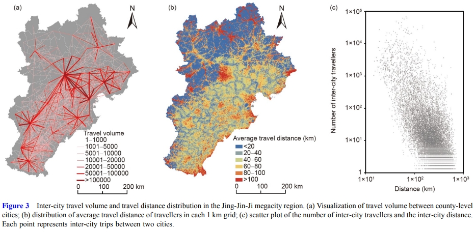
Zhao, P., Hu, H., Zeng, L., Chen, J., & Ye, X. (2023). Revisiting the gravity laws of inter-city mobility in megacity regions. Science China Earth Sciences, 66(2), 271-281.
We revisited the gravity laws of inter-city mobility using the 2.12 billion trip chains recorded by 40.48 million mobile phone users’ trajectories in the Jing-Jin-Ji Region, which contains China’s capital Beijing. Firstly, unlike previous studies, we found that non-commuting rather than commuting is the dominant type of inter-city mobility (89.3%). Non-commuting travellers have a travel distance 42.3% longer than commuting travellers. Secondly, we developed more accurate gravity models for the spatial distribution of inter-city commuting and non-commuting travel. We also found that inter-city mobility has a hierarchical structure, as the distribution of inter-city travel volume follows Zipf’s law. In particular, the hierarchy of non-commuting travel volume among the cities is more in line with an ideal Zipf distribution than commuting travel.
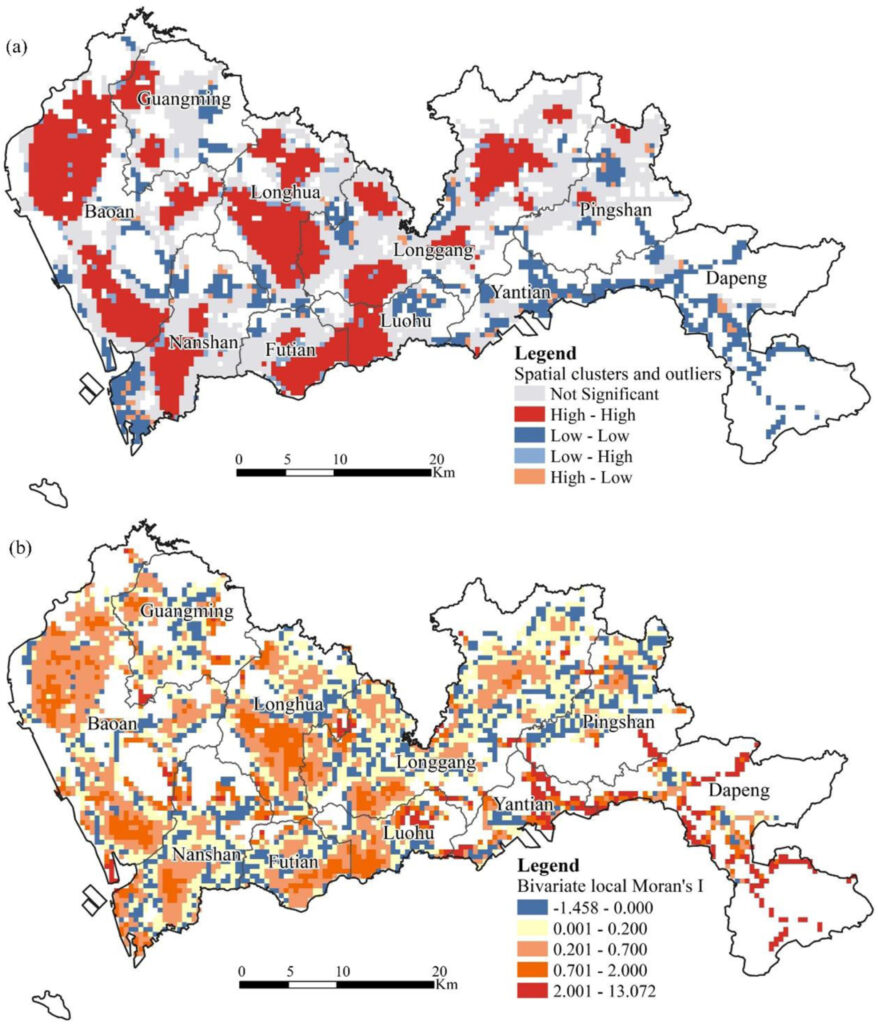
Wu, C., Ye, Y., Gao, F., & Ye, X. (2023). Using street view images to examine the association between human perceptions of locale and urban vitality in Shenzhen, China. Sustainable Cities and Society, 88, 104291.
In this study, EasyGo data provided by Tencent, are used to distinguish differences in daytime and nighttime vitality in Shenzhen, China. Then, a series of subjective and objective variables is calculated to reflect human perceptions of locale based on street view images (SVIs). Finally, random forest and spatial lag regressions are adopted to analyze the driving forces of urban vitality. The results suggest that differences in urban vitality are manifestations of the unbalanced allocation of urban function, accessibility, building form, and human perceptions. The dominant variable category is urban function. There are obvious distinctions between daytime and nighttime vitality, particularly because the human perception category is increasingly important to nighttime vitality.
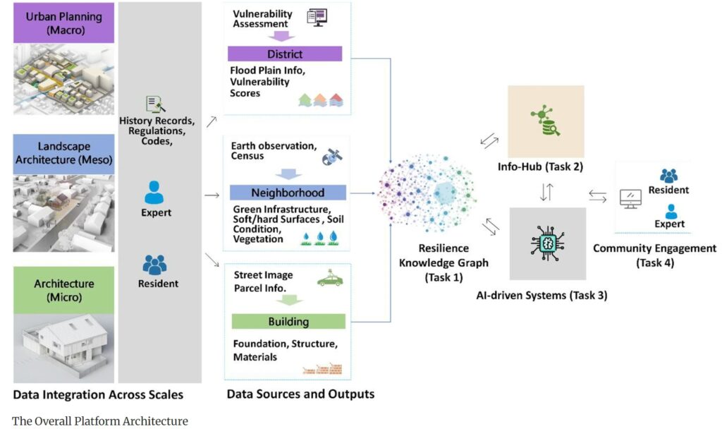
Ye, X., Wang, S., Lu, Z., Song, Y., & Yu, S. (2021). Towards an AI-driven framework for multi-scale urban flood resilience planning and design. Computational urban science, 1, 1-12.
This paper suggests an AI (Artificial Intelligence)-driven platform to facilitate the flood resilience design and planning. This platform, with the active engagement of local residents, experts, policy makers, and practitioners, will break the aforementioned silos and close the knowledge gaps, which ultimately increases public awareness, improves collaboration effectiveness, and achieves the best design and planning outcomes. We suggest a holistic and integrated approach, bringing multiple disciplines (architectural design, landscape architecture, urban planning, geography, and computer science), and examining the pressing resilient issues at the macro, meso, and micro scales.
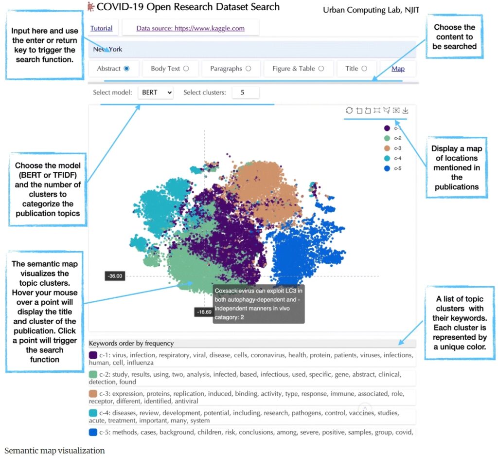
Ye, X., Du, J., Gong, X., Na, S., Li, W., & Kudva, S. (2021). Geospatial and semantic mapping platform for massive COVID-19 scientific publication search. Journal of Geovisualization and Spatial Analysis, 5, 1-12.
Thousands of results of scientific publications on the topic of COVID-19 have emerged within a short time, raising significant challenges for scholars to organize the research, or even synthesize the knowledge in a timely or comprehensive manner. To facilitate this, we have developed a geospatial and semantic mapping platform to search and organize these large and unmapped digital collections. The semantic map visualizes research topics based on customized natural language processing algorithms, which helps users to identify their content of specific interest beyond keyword searches in web search engines. The resultant geospatial map extracts all the location names mentioned in the publications, illustrating where COVID-19 studies have been conducted and where neglected study areas might exist. The system has been deployed as a web service for public access.
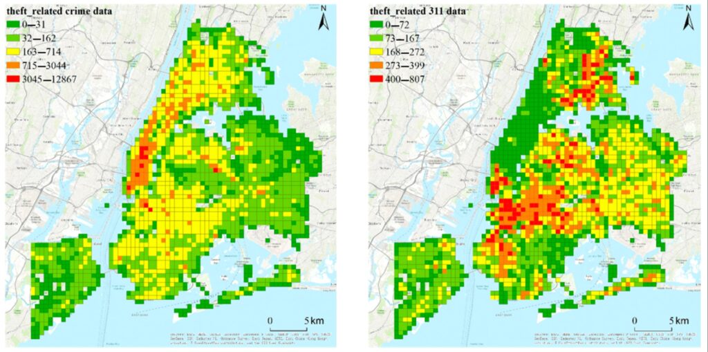
Ye, X., Duan, L., & Peng, Q. (2021). Spatiotemporal prediction of theft risk with deep inception-residual networks. Smart Cities, 4(1), 204-216.
Spatiotemporal prediction of crime is crucial for public safety and smart cities operation. As crime incidents are distributed sparsely across space and time, existing deep-learning methods constrained by coarse spatial scale offer only limited values in prediction of crime density. This paper proposes the use of deep inception-residual networks (DIRNet) to conduct fine-grained, theft-related crime prediction based on non-emergency service request data (311 events). Specifically, it outlines the employment of inception units comprising asymmetrical convolution layers to draw low-level spatiotemporal dependencies hidden in crime events and complaint records in the 311 dataset. Afterward, this paper details how residual units can be applied to capture high-level spatiotemporal features from low-level spatiotemporal dependencies for the final prediction. The effectiveness of the proposed DIRNet is evaluated based on theft-related crime data and 311 data in New York City from 2010 to 2015. The results confirm that the DIRNet obtains an average F1 of 71%, which is better than other prediction models.
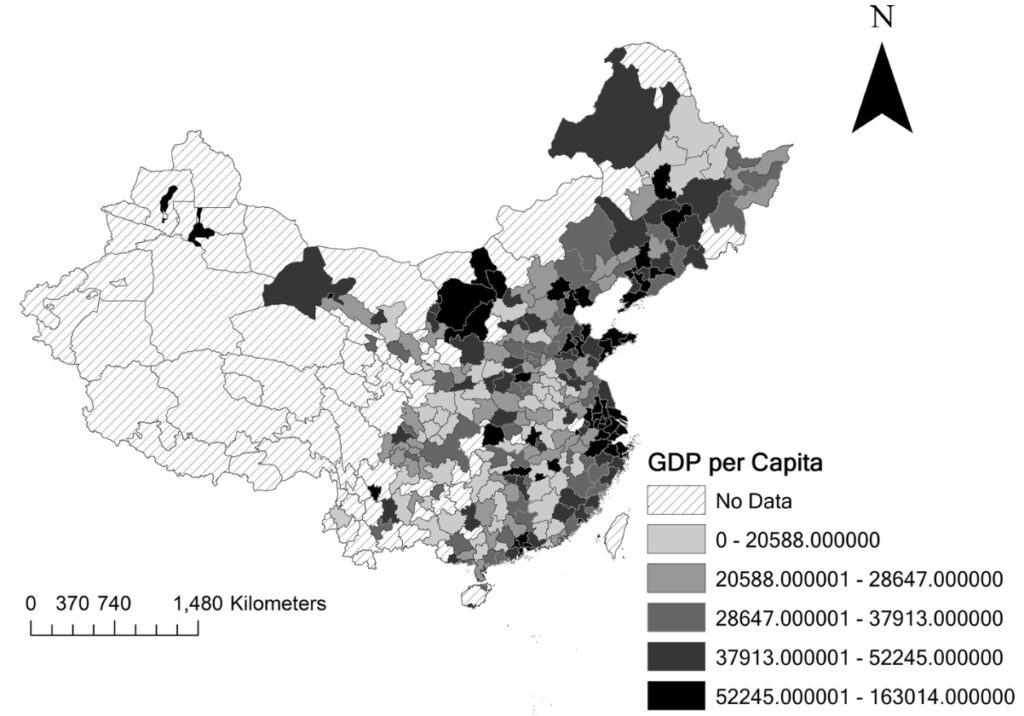
Ye, X., Lian, Z., She, B., & Kudva, S. (2020). Spatial and big data analytics of E-market transaction in China. GeoJournal, 85, 329-341.
This study uses a big data approach and gravity model to quantify the scope and sources of online transactions in urban China and explore the driving forces, based on data from the Taobao platform for online cellphone transactions from June to December in 2011. Comparison among Jing-Jin-Ji Region, Yangtze River Delta, and Pearl River Delta shows that a higher level of economic development corresponds to the more developed logistics industry and more C2C Taobao shops. The regression results illustrate that distance, GDP, and population density are the three main factors which influence the volume and number of trades in the e-marketplace. The number and reputation of traders by relative value also promote the volume and numbers of trades significantly. Additionally, the big data from the Taobao platform provides evidence that the gravity model is valid in estimating the amounts of online transactions.
Ye, X., She, B., Li, W., Kudva, S., & Benya, S. (2020). What and Where Are We Tweeting About Black Friday?. Urban and Regional Planning and Development: 20th Century Forms and 21st Century Transformations, 173-186.
Most studies on Black Friday have largely relied on survey or sales data from case studies of specific cities, which are lack of spatial-temporal granularity. The recent development of location-aware technologies has enabled what Goodchild described as “humans as sensors”, and as a result there has been a large volume of volunteered geographic information with explicitly spatial and temporal tags. Mining these rapidly growing and timely data in the context of space-time synthesis provides a new perspective for understanding the pulse of shopping behavior. In this chapter, we analyze Black Friday patterns and trends in the USA using a dataset retrieved from Twitter. A spatial-temporal analysis of tweeting patterns is conducted. This study tries to discern patterns of tweets on Black Friday in a comparative context.
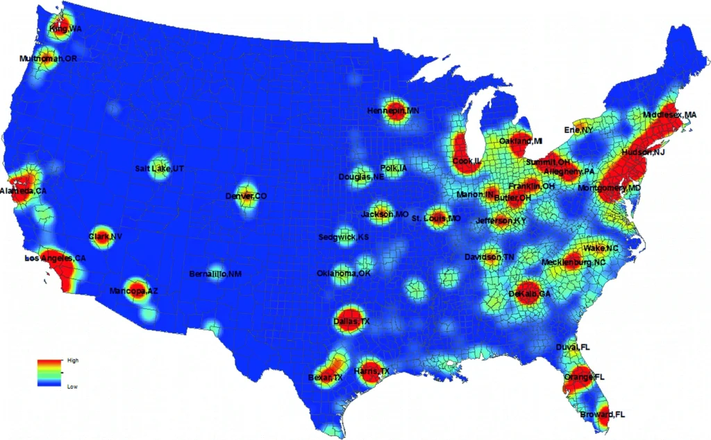

Ye, X. (2019, December). Building Relatively Small Settlements’ Capability for Disaster Response by a Human Dynamics-based Crowd-sourced Real-time Information Sharing System. In SUS-RURI: Proceedings of a Workshop on Developing a Convergence Sustainable Urban Systems Agenda for Redesigning the Urban-Rural Interface along the Mississippi River Watershed held in Ames, Iowa, August 12–13, 2019. PubPub.
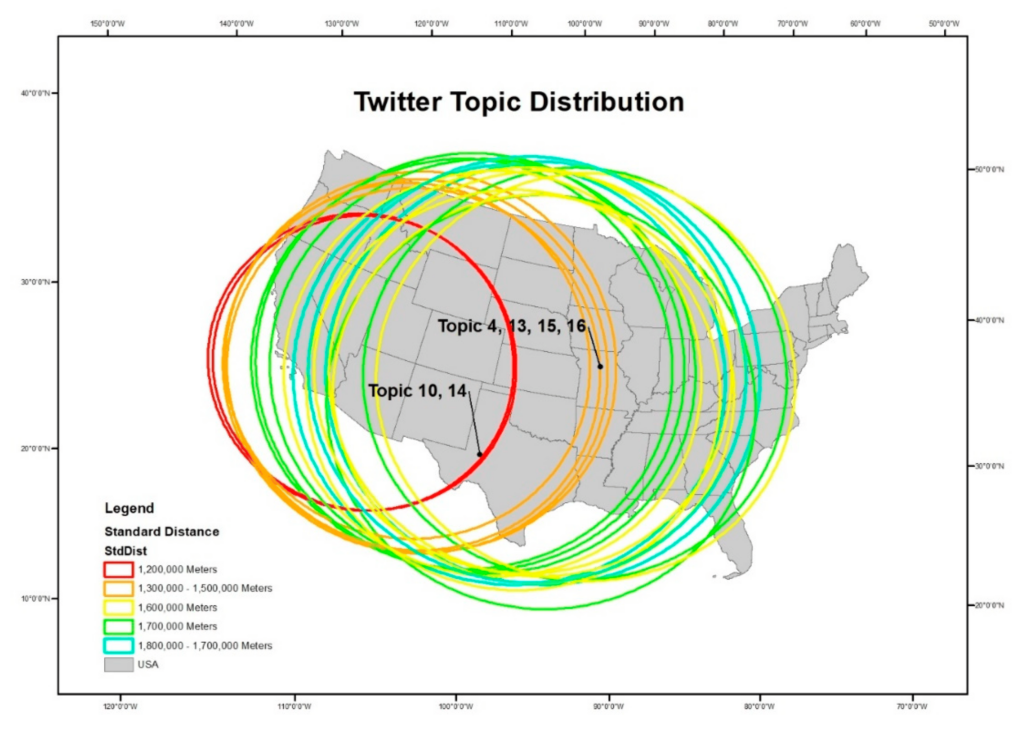
Ye, X., & Wei, X. (2019). A multi-dimensional analysis of El Niño on Twitter: Spatial, social, temporal, and semantic perspectives. ISPRS International Journal of Geo-Information, 8(10), 436.
This paper investigates how El Niño, an extreme recurring weather phenomenon, was discussed on Twitter in the United States from December 2015 to January 2016. A multiple-dimensional analysis, including spatial, social, temporal, and semantic perspectives, is conducted to comprehensively understand Twitter users’ discussion of such weather phenomenon. We argue that such multi-dimensional analysis can reveal complicated patterns of Twitter users’ online discussion and answers questions that cannot be addressed with a single-dimension analysis. For example, a significant increase in tweets about El Niño was noted when a series of rainstorms inundated California in January 2016. Some discussions on natural disasters were influenced by their geographical distances to the disasters and the prevailing geopolitical environment.
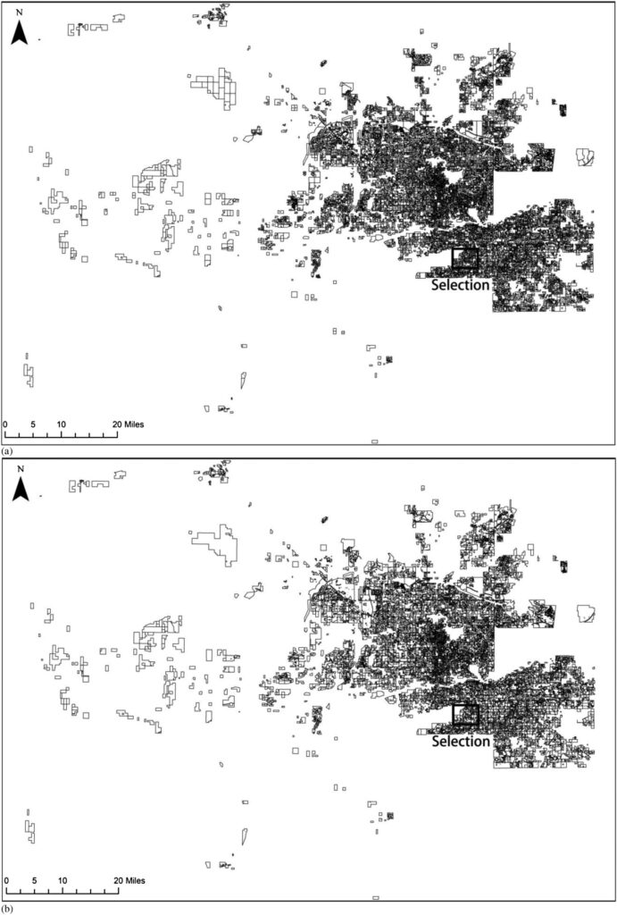
Ye, X., Turner, V. K., & She, B. (2018). Automating land parcel classification for neighborhood-scale urban analysis. International Journal of Digital Earth.
Homeowners’ Associations (HOAs) dictate landscape structure and management through legally enforceable land covenants at the neighborhood scale in the USA. Determining the location and spatial extent of HOAs is critical for examining its influence. However, such analysis is confounded by the lack of spatial data at the appropriate unit for such analysis. The purpose of this paper is to develop and realize an open source implementation to automate land parcel classification, which is an initial step towards the goal of determining the impact of HOAs on urban land management. Using Maricopa County, Arizona as a testbed, we found that parcel merging processes reduce the number of subdivisions from 26,042 to 17,269, such that boundaries better align with neighborhood units to which rule sets like land covenants apply. Moreover, after an initial training period, this process was completed in just over 7 hours. This research is an important first step in enabling a number of analysis including determining the location and spatial extent of HOAs regionally and, eventually, nationally and determining proposed links between HOAs and land management outcomes.
Ye, X., Sharag-Eldin, A., Spitzberg, B., & Wu, L. (2018). Analyzing public opinions on death penalty abolishment. Chinese Sociological Dialogue, 3(1), 53-75.
A meme consists of any words or images in a text that can be replicated across communicators in the exchange of information. This study tests the Multilevel Model of Meme Diffusion (M3D) in a case study in the digital electronic technology that captures the controversial opinions regarding death penalty abolishment in Nebraska. The objective is to demonstrate that an internet-based study using social media data can be used to analyze and predict social processes engaging with phenomena in real space. The authors utilize the meme death_penalty in Twitter texts to predict public perception of death penalty abolishment in Nebraska. The M3D theory integrates the fields of geography and computer-mediated communication technology to explain and predict public opinion on the death penalty.
Ye, X., Li, S., Yang, X., Lee, J., & Wu, L. (2018). The fear of Ebola: A tale of two cities in China. Big Data Support of Urban Planning and Management: The Experience in China, 113-132.
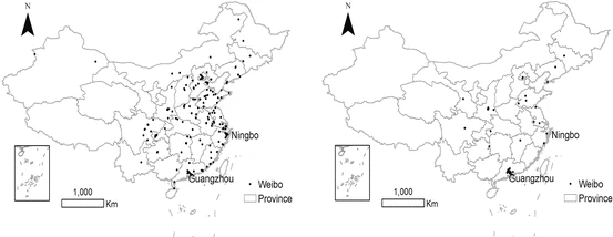
We use the diffusion of Ebola rumors in social media networks as a case study. The topic of rumors is identified based on latent Dirichlet allocation method, and the diffusion process is explored using the space-time methods. By comparing Ebola rumors in the two cities, the chapter explores the relationship between the spread of rumors, user factors, and contents. The results show that: (1) rumors have a self-verification process; (2) rumors have strong aggregation characteristics, and similar rumors in different regions at the same period of time will lead to a synergistic effect; (3) non-authenticated users are more inclined to believe the rumors, while the official users play a major role in stopping rumors as they pay more attention to the fact; (4) the spread and elimination of rumors largely depend on the users who have more followers and friends; and (5) the topics of rumors are closely related to the local event.
Ye, X., Wu, L., & Lee, J. (2017). Accounting for spatiotemporal inhomogeneity of urban crime in China. Papers in Applied Geography, 3(2), 196-205.
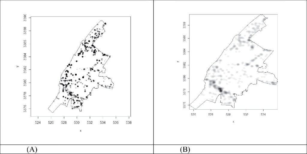
The omission of inhomogeneity for analyzing spatiotemporal trends of a point process could lead to wrongful conclusions regarding how geographic events are distributed and evolve in localized contexts. To address this issue, we apply an inhomogeneous point process (IPP) to address the context of a point process that is nonconstant in spatial and temporal intensity. Extending from the widely used Ripley’s K function, which is often employed to detect spatial clusters in a point pattern, we discuss here a spatiotemporal inhomogeneous K function (STIK). To illustrate the usage and the effectiveness of STIK to analyze point processes, we present a series of analyses using the locations of reported urban crime in Wuhan, China.
Ye, X., Li, S., Yang, X., & Qin, C. (2016). Use of social media for the detection and analysis of infectious diseases in China. ISPRS International Journal of Geo-Information, 5(9), 156.
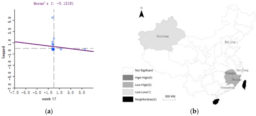
Social media activity has become an important component of daily life for many people. Messages from Twitter (US) and Weibo (China) have shown their potential as important data sources for detecting and analyzing infectious diseases. Such emerging and dynamic new data sources allow us to predict how infectious diseases develop and evolve both spatially and temporally. We report the dynamics of dengue fever in China using messages from Weibo. We first extract and construct a list of keywords related to dengue fever in order to analyze how frequently these words appear in Weibo messages based on the Latent Dirichlet Allocation (LDA). Spatial analysis is then applied to detect how dengue fever cases cluster spatially and spread over time.
Ye, X., She, B., Wu, L., Zhu, X., & Cheng, Y. (2014). An open source toolkit for identifying comparative space-time research questions. Chinese Geographical Science, 24, 348-361.
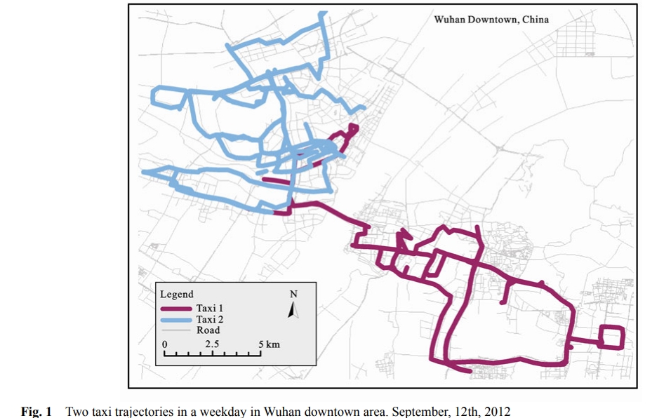
The proposed framework will address this need by developing a set of research questions based on space-time-distributional features of socioeconomic datasets. The authors aim to develop, evaluate, and implement this framework in an open source toolkit to comprehensively quantify the changes and level of hidden variation of space-time datasets across scales and dimensions. Free access to the source code allows a broader community to incorporate additional advances in perspectives and methods, thus facilitating interdisciplinary collaboration. Being written in Python, it is entirely cross-platform, lowering transmission costs in research and education.
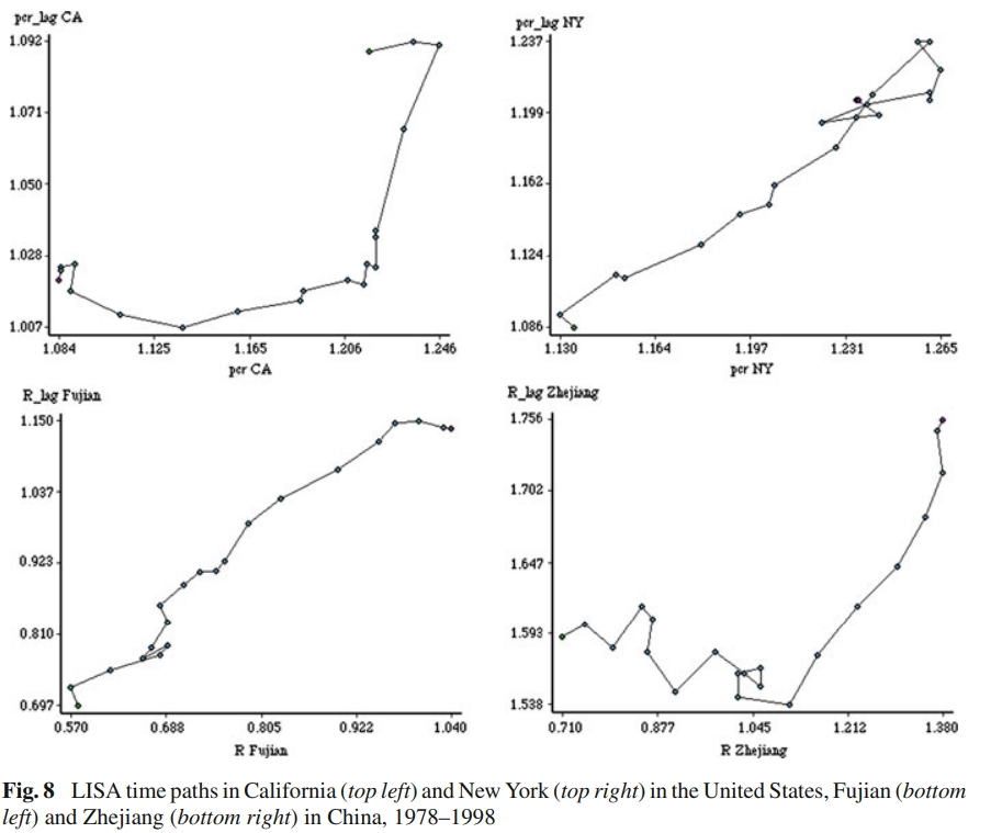
Ye, X., & Rey, S. (2013). A framework for exploratory space-time analysis of economic data. The Annals of Regional Science, 50, 315-339.
This paper thus suggests a novel way to generalize the characteristics and the structure of space-time data sets, using regional economic data as the example. Accordingly, a reasonable number of general questions (data analysis tasks) can be abstracted. Then, tools (methods) may be suggested on that basis. The cross-fertilization between exploratory spatial data analysis (ESDA) and spatial economics is also identified and illustrated by the capabilities of these components, which have uncovered some interesting patterns and trends in the spatial income data of China and the United States. Through exploratory analysis of economic data, the detection of rich details of underlying geographical and temporal processes would be the first step toward such cross-fertilization.
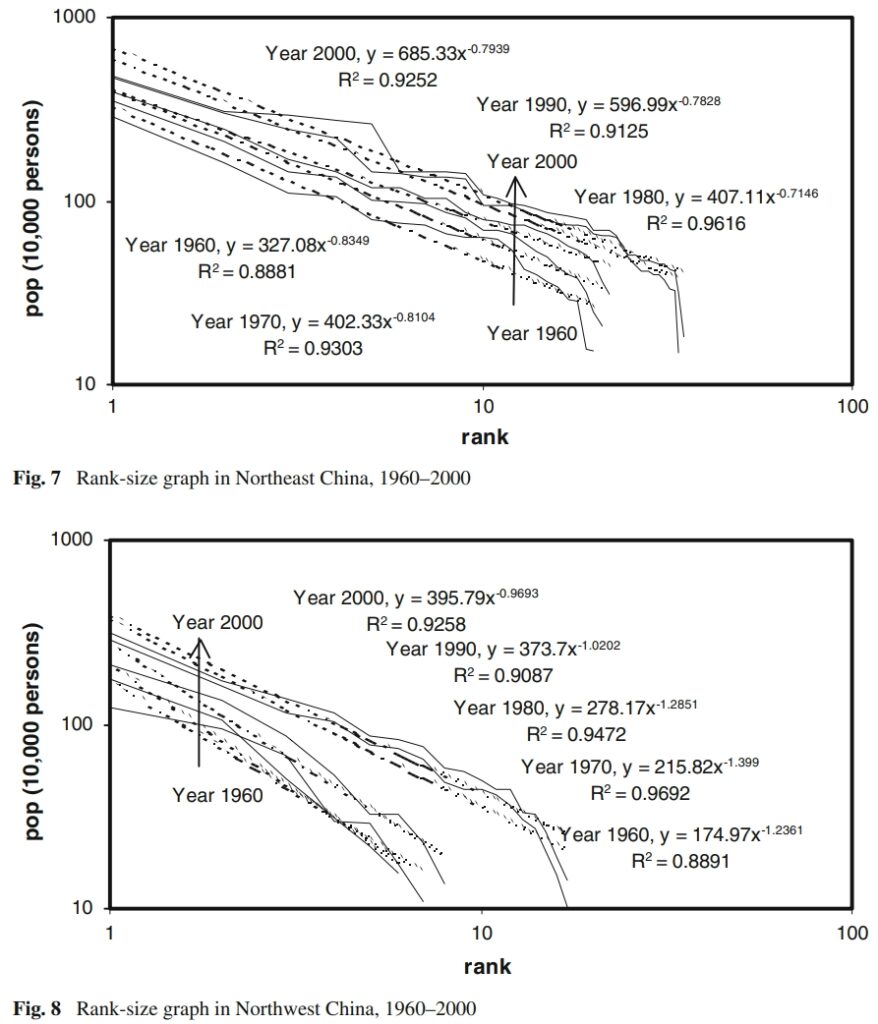
Ye, X., & Xie, Y. (2012). Re-examination of Zipf’s law and urban dynamic in China: a regional approach. The Annals of Regional Science, 49, 135-156.
Recent efforts have been made to interpret spatial-temporal evolution of urban system using Zipf’s law. The debates remain whether Zipf’s law holds true for large and diverse countries with long urbanization history, and how varied geographical settings with different socioeconomic conditions affect city-size distributions. This research investigates China’s urban system dynamics through expanded Zipf’s law at national and regional level. First, the paper revisits urban system dynamic theories and recent applications of Zipf’s law. The city data from 1960 to 2000 are then used to analyze rapid changes of urban systems in China through Zipf’s plots of cities over the entire nation and in six macro regions, respectively. The paper also examines top ten city rank changes nationally and regionally to examine temporal trajectories of key cities and the impacts on urban systems over space. Three types of Zipf’s law reflections are found over six China’s macro regions, based on the similarities of temporal dynamics of urban systems.
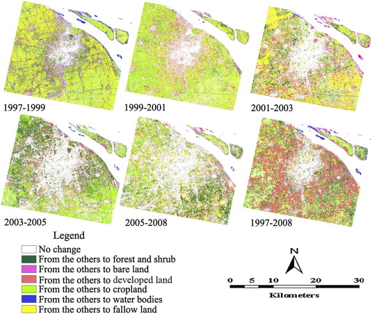
Zhang, H., Qi, Z. F., Ye, X. Y., Cai, Y. B., Ma, W. C., & Chen, M. N. (2013). Analysis of land use/land cover change, population shift, and their effects on spatiotemporal patterns of urban heat islands in metropolitan Shanghai, China. Applied Geography, 44, 121-133.
Using time series Landsat TM/ETM+ imagery and demographic data of Shanghai for 1997 and 2008, the relationship between land use/land cover (LULC) change and population shift and their effects on the spatiotemporal patterns of urban heat islands (UHIs) were quantitatively examined using an integrated approach of remote sensing, geographical information systems (GIS), and statistical analysis.
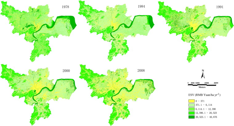
Wu, K. Y., Ye, X. Y., Qi, Z. F., & Zhang, H. (2013). Impacts of land use/land cover change and socioeconomic development on regional ecosystem services: The case of fast-growing Hangzhou metropolitan area, China. Cities, 31, 276-284.
This study analyzes land use dynamics, spatiotemporal patterns of ecosystem service value (ESV), and the forces driving growth in the Hangzhou metropolitan area (HMA) in China. An integrated approach utilizing a Geographic Information System (GIS) and Remote Sensing (RS) was used to extract information on land use/land cover (LULC) change over the period of 1978–2008 from time-series Landsat MSS/TM/ETM+ imagery.
