
Han-Hsun (Jack) Lu remarks that “It is hard work waiting in 100 degrees outside collecting data.”
Yet, based on the problems he and his fellow lab mates solve within their research, it appears that weather is probably the least challenging one.
Jack Lu is a master’s student working in Dr. Valasek’s Vehicle’s System and Control Laboratory within aerospace engineering. The research that the lab pursues is not at all trivial. The group endeavors to create an open architecture system in which both aerial and ground unmanned vehicles autonomously work together to complete a common task.
This open architecture system enables the project to have a vast array of real-world applications. However, in the case of their particular study, the vehicles’ objective is to collect data about crop development within an entire field. For such a straightforward task, numerous logistical components must be identified and overcome.
During the GEOSAT seminar, Jack kindly demonstrated the overall project development and a few logistical aspects that have been refined and identified.
One particular aspect discussed was the challenges posed by mounted sensors. A variety of sensors are mounted to the unmanned vehicles and flown over the fields during their tests. These sensors collect infrared, multi-spectral, and hyperspectral images. The images are then used to evaluate the plants’ traits and development. Each sensor has different mounting and operational needs. For example, a camera may only be able to collect quality data under a certain speed; therefore, the vehicle must autonomously know at which speed it needs to operate. Furthermore, the lab often uses the same unmanned vehicles to collect various types of data sets during a single visit. Indicating that the vehicles and various mounts need to be versatile enough to adapt quickly to each sensor. Additional hardware issues, such as limited battery life, limited or inexistent wireless networks, the rate of data transfer, among others, are some components in which the lab overcomes.
However, Jack outlines that one of the trickiest aspects is the software and programming components. Capturing all of the components of the system’s needs can be a real challenge and doing so in real-time is even harder. The lab has to consider the vehicles’ needs, the sensors needs, the communication needs between the vehicles and the control center, the data’s needs, and much more; and all of these components have to be embedded into the program so that eventually the vehicles can reach full autonomy.
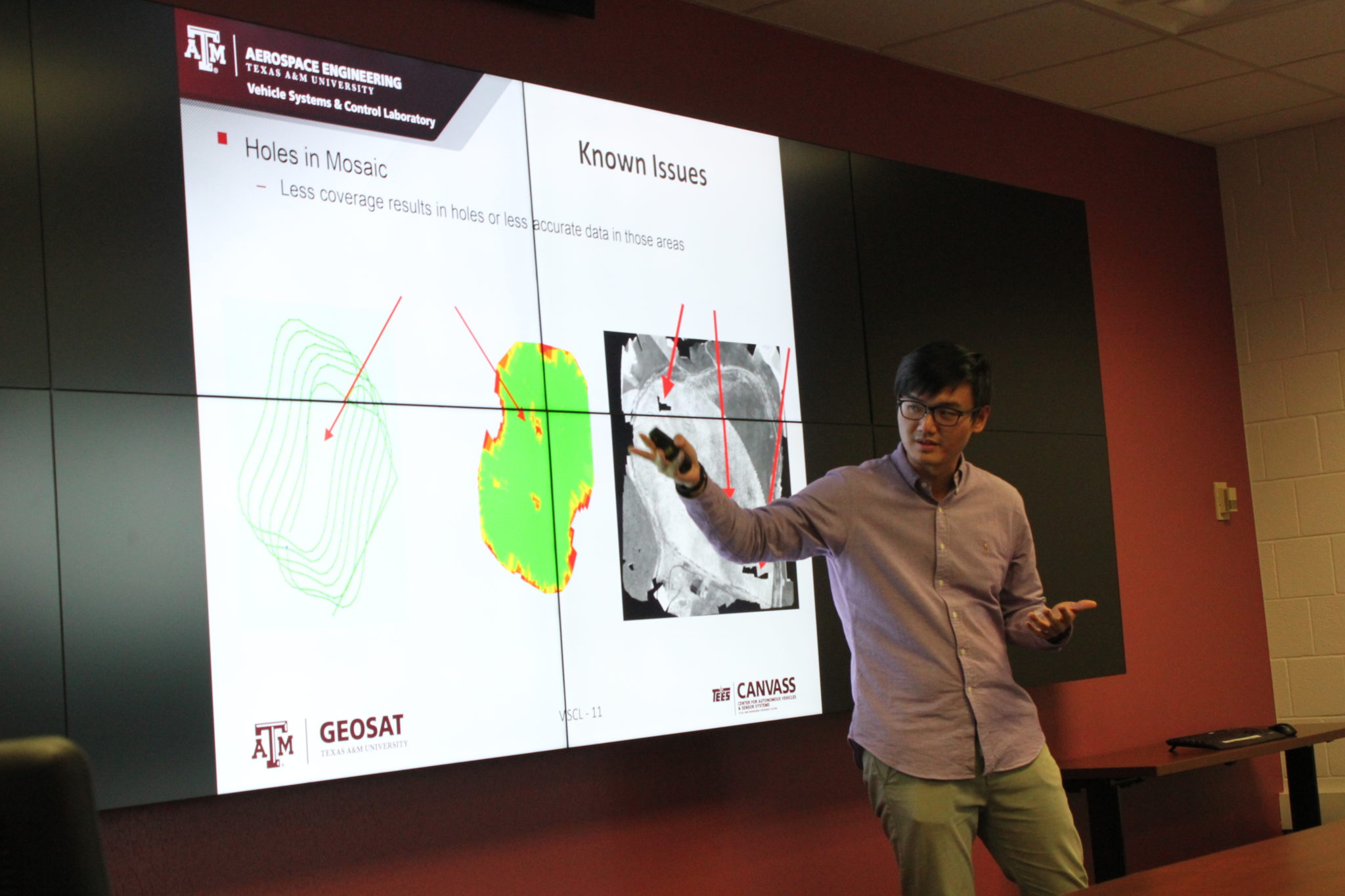
One example of a software need is real-time analysis of the incoming data. When in the field, the vehicles go out and collect data; but when the researchers take the collected data and return to the lab to conduct a data analysis, they realize that either the data quality is low or incomplete. Perhaps the image the sensor took of that particular region was blurry or completely missing because a gust of wind pushed the vehicle during data collection. Jack outlining the problem explains that the researchers might not be able to go back and collect the missing data points until a few weeks later; and at that point, the crops’ characteristics would have already changed. Therefore, the lab needs an analysis to be conducted onsite and in real-time so the vehicle can adjust and compensate for this mistake during data collection. This places new pressures on the system’s hardware and software’s abilities. The researchers need to speed up data transfer rates from the vehicle to the control center conducting the analysis. They have to maximize the analysis’ running time so that conclusions about the data quality can be made quickly, and lastly, the program needs to issue the right commands so that the vehicles can return to the region in which the data point was missing.
Even with these various challenges, the research group continues advancing forward their system to complete autonomy. This is encouraging because the potential impact this project has for a variety of industries, not just agriculture, is very high. For example, this open architecture system of autonomously operating vehicles could be used to better manage crop development and disease control, assess the impact of a natural disaster such as a landslide or hurricanes, collect geographical information about remote locations such as deserts or mountain ranges, and more. For this reason, the lab is excited to push their system’s capabilities, and the GEOSAT center is eager to see them achieve their goal!
To learn more about the research project, visit the lab’s website at https://vscl.tamu.edu/. If interested in attending a seminar, visit GEOSAT’s event page.
Contributing Author: Rachel Holanda